Landscape architects are keenly aware of the restorative qualities, whether behavioral, ecological, or societal, that are inherent in the design and functioning of our built environments.
We see the outcomes of human actions on the earth’s ability to respond to significant natural events, and raise awareness about the ecological benefits in protecting natural systems that mitigate the impact of these events.
Landscape architects are ideally positioned to lead the charge and restore ecological function to our built environments, while at the same time creating inspirational places that link us to our past and our future; reinforcing community connections through civic engagement; providing opportunities for active and passive play; and educating us about our surroundings.
We are constantly developing new methodologies for incorporating these principles into every aspect of planning and design through a wide range of project types including: parks, civic campuses, memorials, housing developments, urban infrastructure, primary schools, site restoration, public art installations, and small scale interventions.
The projects highlighted in this exhibit illustrate the significant contribution landscape architects have made to improve our built environment and move us toward a more sustainable future.
The second annual exhibition and fundraiser event launched on October 8th 2012 in Gould Court. Our exhibition featured 37 projects from 27 firms/non-profits. Over a hundred design professionals, students, faculty, and alumni gathered to view the inspiring breadth of work on display.
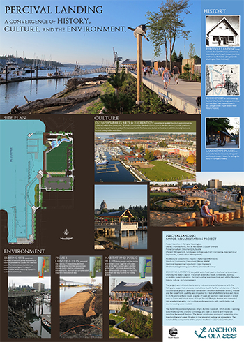
Title: Percival Landing: A Convergence of History, Culture, and the Environment
Project: Percival Landing Major Rehabilitation Project
Firm: Anchor QEA, Seattle
Summary: Percival Landing is a public waterfront park in the heart of downtown Olympia, the state’s capitol. The crown jewel of a larger, connected, publicly accessible waterfront vision, Percival Landing is an important part of Olympia’s history, culture, and environment.
The project was initiated due to safety and environmental concerns with the failing pile-supported, creosote-treated boardwalk. Further deficiencies of the site included poor physical and visual connections between downtown streets, the site and the waterfront; usability was impacted by a lack of sheltered areas and places to sit. To address these issues, a series of open air pavilions were placed at street ends to frame and orient views of Puget Sound. Olympia Avenue was converted into a pedestrian entry, and multiple landscape rooms with comfortable and diverse seating were created.
The materials palette emphasizes simple durable materials, which evoke a working waterfront. Lighting and site furnishings are used as accents with materials matching the overall themes. The design emphasizes ecological restoration along the shoreline and water filtration in the relocated parking lot rain gardens. The sustainability components of the project resulted in LEED Gold Certification.
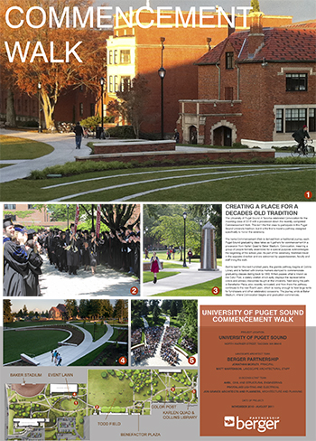
Title: Commencement Walk
Project: University of Puget Sound Commencement Walk
Firm: Berger Partnership
Summary: The University of Puget Sound in Tacoma celebrated Convocation for the incoming class of 2015 with a procession down the recently completed Commencement Walk. This isn’t the first class to participate in this Puget Sound University tradition, but it is the first to travel a pathway designed specifically to honor the ceremony.
The name Commencement Walk is derived from a traditional journey each Puget Sound graduating class takes as it gathers for commencement in a procession from Karlen Quad to Baker Stadium. Convocation, meaning a group of people formally assembled for a special purpose, acknowledges the beginning of the school year. As part of the ceremony, freshmen travel in the opposite direction and are welcomed by upperclassmen, faculty and staff lining the walk.
Built to last for the next hundred years, the granite pathway begins at Collins Library and is flanked with bronze markers stamped to commemorate graduating classes dating back to 1893. It then passes what is known as the Color Post, a stately obelisk which aptly displays the representative colors and primary disciplines taught at the University. Next along the path is Benefactor Plaza, also recently renovated, and from there the pathway continues to the new Event Lawn, which is roomy enough to host large tents for fundraisers and other celebratory occasions. The journey ends at Baker Stadium, where Convocation begins and graduation commences.
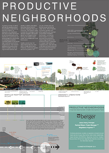
Title: Productive Neighborhoods
Project: A Case Study Based Exploration of Seattle Urban Agriculture Projects
Firm: Berger Partnership
Summary: A growing number of clients are asking questions about incorporating urban farming into their projects. As designers, we understand the value of urban farming for its environmental and social benefits for a community, but acknowledge the complexities of creating a successful commercial farm to provide an über local food source for a neighborhood. This research explores the existing urban farms in Seattle, as well as regional and national case studies, to better understand how urban farms function and the challenges they must overcome. The research seeks to share the knowledge of each site and instigate a discussion about how to expand urban farming into Seattle’s food system as a reliable über local food source.
Seattle currently has 103 urban food production sites, which include urban farms, P-Patches, community gardens and school gardens, but only ten of these sites are functioning as commercial urban farms. While P-Patches, community gardens and school gardens are important components of Seattle’s food system, commercial farms located in an urban area have the potential to make a large impact on the local food supply. If practiced on a larger scale within our neighborhoods, urban farming could shift our food production toward a balanced, localized and sustainable network.
Title: Designing a comprehensive recreation facility for the year 2038
Project: Park Master Plan: Gillette, Wyoming
Firm: Bruce Dees & Associates
Summary: The city of Gillette and Campbell County, Wyoming have experienced significant growth in population and are projected to grow from the current population of 28,900 citizens to 50,000 citizens by the year 2038. Consequently, increased demand for park and recreation services and facilities for both Campbell County and the city of Gillette is expected.
With anticipated growth of Gillette their recently completed parks and pathways plan showed an existing deficiency of fields. The city council acquired a 320 acre “Field of Dreams” site on the east side of the city for development of sports fields and other facilites to meet the future demand. In 2011 the city formed a task force of city leader and potential partners to plan the development of the site.
Title: Increasing engagement and energy in the recreational experiences of all students
Project: Seattle University Park: Seattle, WA
Firm: Bruce Dees & Associates
Summary: Logan Field on the south side of the Seattle University Campus has been a well loved place for students, alumni, and the community since its establihsment. Increased demand however, resulted in an awareness of the limitations on playability of the facility. A recent renovation addressed the limitations and the new Seattle University Park featuring Logan Field is an amenity that has greatly increased the recreation capabilities of the university while providing increased opportunities for the student body on campus.
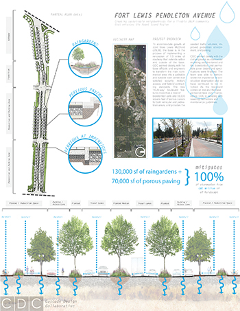
Title: Fort Lewis Pendleton Avenue: Creating sustainable neighborhoods for a livable JBLM community that enhances the Puget Sound Region
Project: Joint Base Lewis McChord Roadway Renovation
Firm: Cascade Design Collaborative (CDC)
Summary: To accommodate growth at Joint Base Lewis McChord (JBLM), the base is in the process of implementing a renovation of 1.5 miles of roadway that extends within and outside of the base. CDC worked closely with the base officials and engineers to transform the main commercial area into a walkable and liveable town center that satisfied security, military access, and federal contracting standards. The new “multi-way” boulevard features more than a mile of bioretention cells and 55,000 square feet of porous pavers for both vehicular and pedestrian areas, and provides the needed traffic volumes, improved pedestrian environment, and parking.
CDC worked closely with the civil engineers as stormwater modeling was fine-tuned and the bioretention and permeable paver details and specifications were finalized. The team was able to demonstrate the importance of construction observation and so have continued to be involved. As the boulevard comes on line and the base personnel take over maintenance, CDC is assisting with weeding instructions and maintenance guidelines.
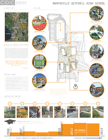
Title: Marysville Getchell High School: A school “built into a forest”
Project: Marysville Getchell High School
Firm: Cascade Design Collaborative (CDC)
Summary: Built around an existing wetland and second growth forest, Marysville Getchell High School is truly unique. This brand new campus was designed to feel as though it was “built into a forest”. Unlike other school campuses, Getchell looks and feels more like an evergreen refuge than an institutional complex. There are five buildings on the site which are connected by a series of elevated walkways and bridges. Along these walkways are several outdoor classrooms, gathering spaces, and raingardens. All of these elements together create an environment that is rich with learning, natural beauty, and creativity.
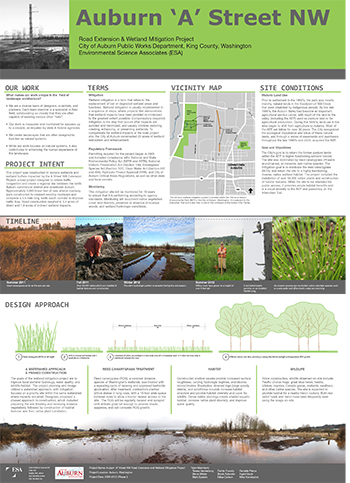
Title: Auburn ‘A’ Street NW
Project: Auburn ‘A’ Street NW Road Extension and Wetland Mitigation Project
Firm: Environmental Science Associates (ESA)
Summary: This project was constructed to replace wetlands and wetland buffers impacted by the A Street NW Extension Project, a road project designed to relieve traffic congestion and create a regional link between the north Auburn commercial district and downtown Auburn. Approximately 2,600 linear feet of new arterial roadway were constructed to connect existing roadways and complete a 3.5-mile long north-south corridor to improve traffic flow. Road construction resulted in 3.3 acres of direct and 1.9 acres of indirect wetland impacts.
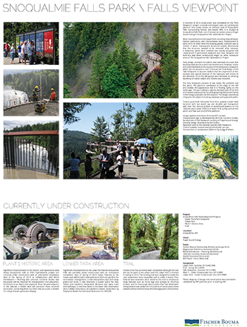
Title: Snoqualmie Falls Park Falls Viewpoint
Project: Snowqualmie Falls Redevelopment Projects: Upper Park/Falls Viewpoint, Lower Park, Plant 1 Historic Area, Trail
Firm: Fischer Bouma Partnership
Summary: In the summer of 2012 construction was completed on the “Falls Viewpoint” project, a simple and elegant open-air cantilevered platform that allows visitors an intimate view of Snoqualmie Falls, surrounding forests, and basalt cliffs. It is located at Snoqualmie Falls Park- one of several recreation areas at Puget Sound Energy’s Snoqualmie Falls Hydroelectric Project. Most improvements to the Upper Park, including new pathways, habitat restoration, and interpretation were implemented in early 2010, at which time the existing gazebo overlook was to remain in place. Subsequent structural studies determined that the structure needed to be removed. After removal, a temporary wood deck overlook was quickly designed and constructed. A permanent viewpoint was then designed and built this year when construction began on other recreation areas of the Snoqualmie Falls Hydroelectric Project.
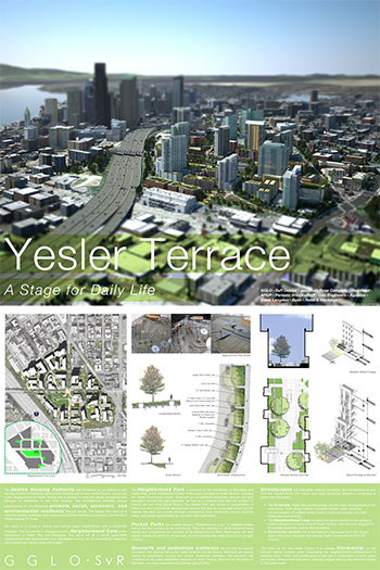
Title: Yesler Terrace: A Stage for Daily Life
Project: Yesler Terrace
Firm: GGLO + SvR
Summary: The Seattle Housing Authority has embarked on an ambitious and exciting mission of replacing aging public housing with a new mixed-income, mixed-use urban neighborhood at Yesler Terrace that is tailored to meet the needs, aspirations and lifestyles of Seattlelites in the 21st Century. The development provides unique opportunities to simultaneously promote social, economic, and environmental resiliency through design. The Master Plan lays out a vision for streets, walkways, open space and buildings that knit a community over the site’s steeply sloping 37 acres.
Our vision is to create a diverse and inviting urban neighborhood with a residential character. The community is arranged around a neighborhood core at the intersection of Yesler Way and Broadway. The result will be a model sustainable neighborhood that demonstrates how affordable housing can be successfully integrated into a vibrant and dense urban infill project.
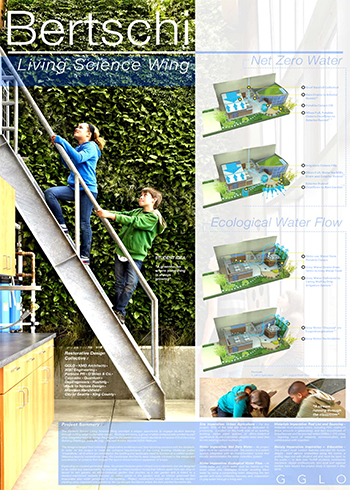
Title: Bertschi: Living Science Wing
Project: Bertschi School Living Building Science Classroom
Firm: GGLO
Summary: The Bertschi School Living Building Science Wing is a state-of-the-art learning environment for students of an independent elementary school in Seattle’s Capitol Hill neighborhood. GGLO provided landscape architectural services as part of the Restorative Design Collective, a group of design professionals formed to raise green building standards by attempting to meet the Living Building Challenge. The project is the first in the state of Washington constructed to meet the Living Building Challenge, the first in the world to target v2.0, and the first urban project constructed to meet the challenge. The Science Wing is a low impact project that generates its own energy, treats its own waste and storm water and provides a healthy learning environment for students.
Focusing on the Living Building Petals of Site, Water, Health and Beauty, our landscape architectural design includes a Green Roof of mosses, Rain Gardens for on-site storm water filtration, Ethno-botanical gardens, a PVC-free irrigation system fed by rain water, and a Living Wall that filters building grey water.
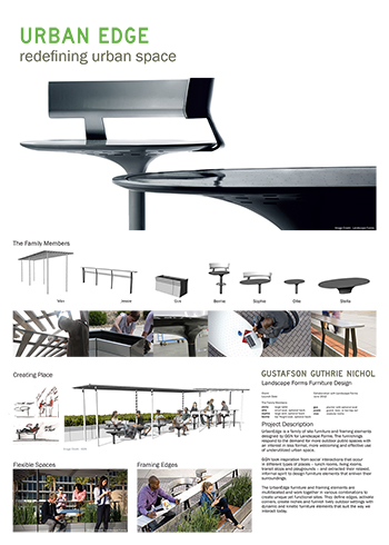
Title: Landscape Forms Furniture Design
Project: UrbanEdge
Firm: Gustafson Guthrie Nichol
Summary: UrbanEdge is a family of site furniture and framing elements designed by GGN for Landscape Forms. The furnishings respond to the demand for more outdoor public spaces with an interest in less formal, more welcoming and effective use of underutilized urban space.
GGN took inspiration from social interactions that occur in different types of places – lunch rooms, living rooms, transit stops and playgrounds – and extracted their relaxed, informal spirit to design furniture elements that enliven their surroundings.
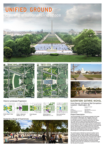
Title: Union Square, US National Mall Competition
Project: US National Mall Competition
Firm: Gustafson Guthrie Nichol
Summary: This winning design for Union Square, situated at the base of the Capitol in Washington, DC, engages visitors with an impressive monumental scale, while also providing comfortable places for a range of experiences and voices. The major focus is a grand central space defined by a reflecting pool and the historic Grand Memorial. Consisting of a 2-inch sheet of water over a paved surface, the pool can be quickly drained to create a range of differently sized assembly spaces. Paved paths running diagonally at the surface of the pool encourage pedestrians to traverse this larger water feature and allow people to inhabit the water’s surface, enlivening and humanizing this formal space.
The central space is flanked by a series of outdoor rooms of distinct character. Subtle changes in grade are used to form terraces and low retaining walls that provide seating surfaces and views into these rooms. Planting further defines the spaces within, utilizing the existing mature trees on the site. Materials have been selected to reinforce the different identities of the constituent spaces, as well as to create durable surfaces that can be efficiently maintained through the life cycle of the project.
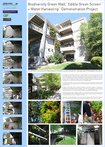
Title: Biodiversity Green Wall, Edible Green Screen and Water Harvesting Demonstration Project
Project: Biodiversity Green Wall, Edible Green Screen and Water Harvesting Demonstration Project
Firm: Green Futures Lab
Summary: The Biodiversity Green Wall, Edible Green Screen and Water Harvesting Demonstration Project is a student-led design, construction and monitoring effort in which the UW Green Futures Lab transformed a blank concrete wall into a showcase of improved habitat that fosters diverse native species, innovated rainwater harvesting methods for irrigation, tried vertical methods of local food production and are testing green systems that will potentially reduce building energy demand to help UW reduce its carbon footprint and achieve its sustainability goals.
The movable Green Wall uses an innovative yet simple pulley system, reflecting the constant flux of ecological processes and allowing the wall to slide to the adjacent balconies for ease of research and maintenance.
Located on Gould Hall which incubates architecture, landscape architecture, construction management, urban design and planning students, this small-scale installation is a demonstration project for the next generation of design professionals. A sustainability “billboard” of sorts, the project highlights the rich ecosystem services provided by a carefully crafted landscape.
The integrated design team included 8 students from 4 different disciplines, working with over 50 supporting faculty and staff and a local green wall manufacturer, SolTerra Systems. Design began in spring 2011, with construction completed in fall 2012.
The project is being monitored for thermal effects on the building, urban heat island mitigation, water conservation and stormwater reduction, biodiversity and plant growth, and human use.
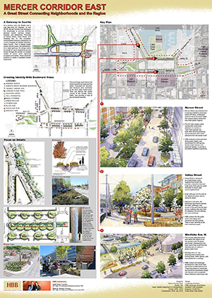
Title: Mercer Corridor East: A Great Street Connecting Neighborhoods and the Region
Project: Mercer Corridor East
Firm: HBB Landscape Architecture
Summary: As a primary entry into Seattle and a vital east-west link between I-5 and SR-99, Mercer Corridor East redesigns the streetscape to alleviate conflicts between transit, vehicles, freight, bicycles, and pedestrians. Focusing on Mercer Street, Valley Street, and Westlake Ave. N., the circulation improvements enhance connections to I-5 and integrate the Seattle Streetcar, Metro Transit, Port of Seattle freight routes, bicycle routes, and pedestrians. As a major gateway, the design seeks to provide an iconic experience as one moves through the corridor at multiple modes of travel, while improving circulation and safety. These elements combine to create a complete street experience.
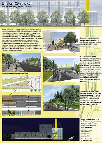
Title: Urban Gateways: South Portal, SR99 Tunnel
Project: SR 99 Tunnel Project
Firm: HNTB Corporation
Summary: This gateway sits as the southern bookend of the Seattle waterfront and emphasizes the point of arrival to the city from the south. Travelers will experience a progression from the forested landscapes of the Puget Sound to the order and rhythm of the city. From there, one transitions to the language of the boulevard emerging with street trees and pedestrian scale environments. The landscaping associated with the tunnel’s South Operations Building establishes the railroad way as a pedestrian and open space corridor, linking the waterfront Pioneer Square and the stadium district. Serving as a prominent beacon, the building’s “safety yellow” ventilation stacks are a striking contrast to the surroundings.
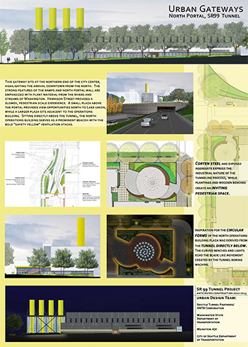
Title: Urban Gateways: North Portal, SR99 Tunnel
Project: SR 99 Tunnel Project
Firm: HNTB Corporation
Summary: The gateway sits at the northern end of the city center, highlighting the arrival downtown from the north. The strong features of the ramps and north portal wall are emphasized with plant material from the rivers and streams of Washington. Harrison Street provides a slower, pedestrian scale experience. A small plaza above the portal provides view opportunities north to Lake Union, while a larger plaza sits adjacent to the operations building. Sitting directly above the tunnel, the North Operations Building serves as a prominent beacon with the bold “safety yellow” ventilation stacks.
![InkwellCollective_ filaments[screenRes]](https://larch.be.uw.edu/wp-content/uploads/sites/88/2015/10/InkwellCollective_-filamentsscreenRes.jpg)
Title: Between Earthworks: Wayfinding in a modified watershed
Project: Earthworks Tour: Filaments
Firm: Inkwell Collective
Summary: The Earthworks Tour: Filaments are designed to navigate the dynamic landscape of the Green River Valley, and to inspire a deeper understanding of landscape restoration and stormwater management in the region. The permanent work shares a rich layering of landscape experience, interpretive imagery and conceptual relationships through 65 unique installations that marks the 24 mile Earthwork Tour. The installation links four seminal landart projects in the Green River Valley into one continuous narrative of water and landuse. Inspired by Herbert Bayer Earthwork, Robert Morris Earthwork, Green River Natural Resources Area and Lorna Jordan’s Waterworks Gardens, the design team applied a bold use of minimal aesthetic to critically engage the experience of place and processes.
Stormwater management is a major concern to residents of Kent, SeaTac, Tukwila and Renton (all within King County and minutes from Seattle). As the Earthworks Tour was being designed, miles of sandbags lined the Green River to prevent floodwaters from damaging homes and property, highlighting the urgency for inspirational alternatives to publicly engage natural processes. Successful repairs to the Howard Hanson Dam have since allowed 12 miles of the sandbags to be removed, yet the enormous costs of government, residents and businesses require continued exploration of how best to manage stormwater in the Green River Valley.
This installation is modernist in its simplicity, yet contemporary in its approach to communicating and gathering ideas via real and virtual means. The bicycle tour is more than a visit to a collection of sites; it is nourished as a series of filaments that weave a collective tapestry of engagement. Cultural tourism, environmental art, digital documentation, social media, interpretive signage, and multi-jurisdictional coordination ensure that this will be a truly radiant example of significant art in the everyday. As participants make their way along the tour, Filaments emphasizes the bond between the earthworks, the region, and its inhabitants. Rider experience, trail context, proximity to the Green River, regional history, community and municipal partnership, and of course the earthworks themselves, have all influenced the direction of the tour. Each element works together to develop scales of rider engagement, allowing rushing commuters, and leisurely strollers to find personalized textures of understanding. Accordingly, the individual installations stand out because of their uniquely minimalist form, careful use of bold color, clear directional cues, and scales of interpretation.
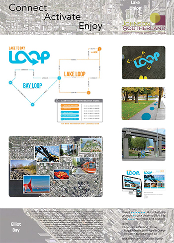
Title: Connect Activate Enjoy: Lake to Bay Loop
Project: Lake to Bay Loop
Firm: Johnson + Southerland
Summary: Have you ever walked from Elliot Bay to Lake Union? It is a historic route between Duwamish Indian villages and now connects some of Seattle’s most exciting landmarks – the Sculpture Park, Seattle Center, and the newly vibrant South Lake Union neighborhood. The idea for the Lake to Bay Loop has been around for decades. The new Thomas Street pedestrian bridge and major street projects are creating connections that make it possible to complete the figure-eight pedestrian loop. How can we “activate” it, get people walking and enjoying local amenities, culture and history? Our challenge from SDOT: with a very limited construction budget, create an identity and effective wayfinding for the Lake to Bay Loop so that people will start to recognize and use the Loop. The logo is incorporated into “wayfinding dots” on existing city sidewalks and into sculptural kiosks at important nodes. A website and phone apps are a platform for layers of historical and cultural information, such as “the legend of the whales” and “Thursday night pub crawls!”
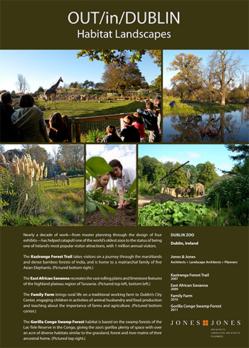
Title: OUT/in/DUBLIN: Habitat Landscapes
Project: Kaziranga Forest Trail, East African Savanna, Family Farm, Gorilla Congo Swamp Forest
Firm: Jones and Jones
Summary: Nearly a decade of work – from master planning through the design of four exhibits – has helped catapult one of the world’s oldest zoos to the status of being one of Ireland’s most popular visitor attractions, with 1 million annual visitors.
The Kaziranga Forest Trail takes visitors on a journey through the marshlands and dense bamboo forests of India, and is home to a matriarchal family of five Asian Elephants.
The East African Savanna recreates the vast rolling plains and limestone features of the highland plateau region of Tanzania.
The Family Farm brings rural life on a traditional working farm to Dublin’s City Center, engaging children in activities of animal husbandry and food production and teaching about the importance of farms and agriculture.
The Gorilla Congo Swamp Forest habitat is based on the swamp forests of the Lac-Tele Reserve in the Congo, giving the zoo’s gorillas plenty of space with over an acre of diverse habitats similar to the grassland, forest and river matrix of their ancestral home.
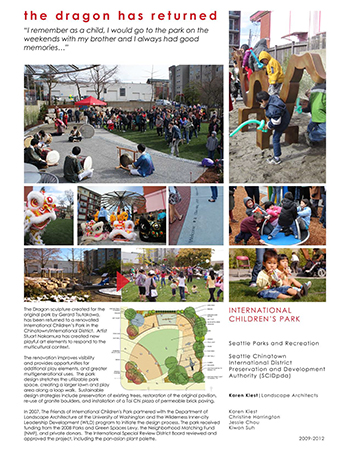
Title: The Dragon Has Returned
Project: International Children’s Park
Firm: Karen Kiest Landscape Architects (KKLA)
Summary: The Dragon sculpture created for the original park by Gerard Tsutakawa, has been returned to a renovated International Children’s Park in the Chinatown/International District. Artist Stuart Nakamura has created new playful art elements to respond to the multicultural context.
The renovation improves visibility and provides opportunities for additional play elements, and greater multigenerational uses. The park design stretches the utilizable park space, creating a larger lawn and play area along a loop walk. Sustainable design strategies include preservation of existing trees, restoration of the original pavilion, re-use of granite boulders, and installation of a Tai Chi plaza of permeable brick paving.
In 2007, The Friends of International Children’s Park partnered with the Department of Landscape Architecture at the University of Washington and the Wilderness Inner-city Leadership Development (WILD) program to initiate the design process. The park received funding from the 2008 Parks and Green Spaces Levy, the Neighborhood Matching Fund (NMF), and private donors. The International Special Review District Board reviewed and approved the project, including the pan-Asian plant palette.
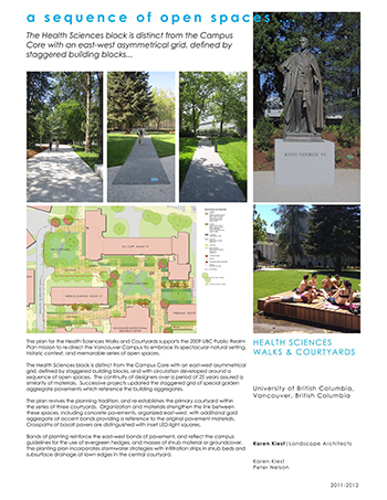
Title: A Sequence of Open Spaces
Project: University of British Columbia: Health Sciences Walks & Courtyards
Firm: Karen Kiest Landscape Architects (KKLA)
Summary: The plan for the Health Sciences Walks and Courtyards supports the 2009 UBC Public Realm Plan mission to re-direct the Vancouver Campus to embrace its spectacular natural setting, historic context, and memorable series of open spaces.
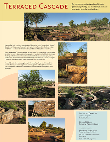
Title: Terraced Cascade
Project: Terraced Cascade – Scottsdale, Arizona
Firm: Lorna Jordan
Summary: Expressed as both miniature watershed and abstraction of the human body, Terraced Cascade provides a means for people to imagine their place within the larger Indian Bend Wash – a watershed with alternating conditions of drought and flooding.
Taking advantage of the topography at the east end of the Indian Bend Wash, a series of rib-like terraces and a vertebrae-like cascade are nestled into the hillside. Xeriscape plantings in the terraces and cascade are selected for their curious shapes, colors, and textures. Harvested stormwater intermittently flows down the cascade to irrigate a mesquite bosque that offers shade and respite from the desert sun.
Terraced Cascade also acts as a gateway to the park. A pathway winds through the artwork allowing visitors to explore the terraces, plants, and sculptural cascades. Low curving walls at the edge of the pathway provide intimate seating areas within the garden.
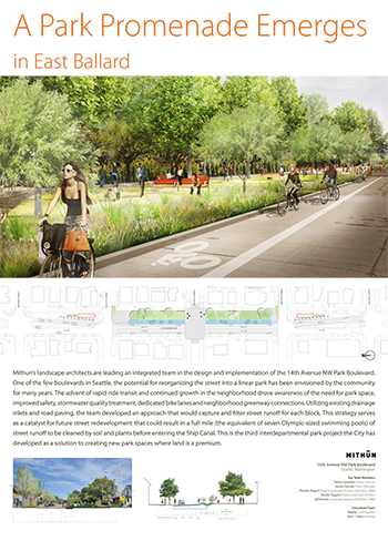
Title: A Park Promenade Emerges in East Ballard
Project: 14th Avenue NW Park Boulevard
Firm: Mithun
Summary: Mithun’s landscape architects are leading an integrated team in the design and implementation of the 14th Avenue NW Park Boulevard. One of the few boulevards in Seattle, the potential for reorganizing the street into a linear park has been envisioned by the community for many years. The advent of rapid ride transit and continued growth in the neighborhood drove awareness of the need for park space, improved safety, stormwater quality treatment, dedicated bike lanes and neighborhood greenway connections. Utilizing existing drainage inlets and road paving, the team developed an approach that would capture and filter street runoff for each block. This strategy serves as a catalyst for future street redevelopment that could result in a full mile (the equivalent of seven Olympic-sized swimming pools) of street runoff to be cleaned by soil and plants before entering the Ship Canal. This is the third interdepartmental park project the City has developed as a solution to creating new park spaces where land is a premium.
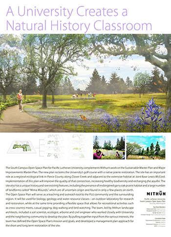
Title: A University Creates a Natural History Classroom
Project: Pacific Lutheran University/ South Campus Open Space Plan
Firm: Mithun
Summary: The South Campus Open Space Plan for Pacific Lutheran University completements Mithun’s work on the Sustainable Master Plan and Major Improvements Master Plan. The new plan reclaims the University’s golf course with a native prairie restoration. The site has an important role as a regional ecological link in Pierce County along Clover Creek and adjacent to the extensive habitat at Joint Base Lewis-McCord. Implementation of this plan will improve the quality of that connection, increasing healthy biodiversity and recharging the aquifer The site also has a unique history and rare existing features, including the presence of endangered garry oak prairie habitat and a large number of landforms called “Mima Mounds”, which are of uncertain origin and found in only a few places on earth. The Open Space Plan will serve as a teaching and outreach tool to the PLU community and the surrounding region. It will be used for biology, geology and water resource classes – an outdoor laboratory for research and restoration, while at the same time providing a flexible space that allows for recreational activities such as cross country meets, casual jogging, dog walking and bird watching. The team, led by Mithun landscape architects, included a soil scientist, ecologist, arborist and civil engineer who worked closely with University and the neighboring community to develop the plan. By pulling together input from the various interests, the team has defined the Open Space Plan’s mission and goals, and developed a management plan approach for the short and long term restoration of the site.
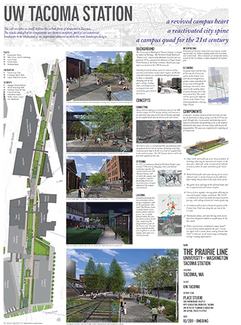
Title: The Prairie Line: University of Washington Tacoma Station
Project: UW Tacoma Station
Firm: Place Studio
Summary: The rail corridor in itself, defines the urban form of downtown Tacoma. The tracks and all of its components are historic artifacts, part of an industrial landscape to be celebrated as an important element within the new landscape design.
A revived campus heart | A reactivated city spine | A campus quad for the 21st century
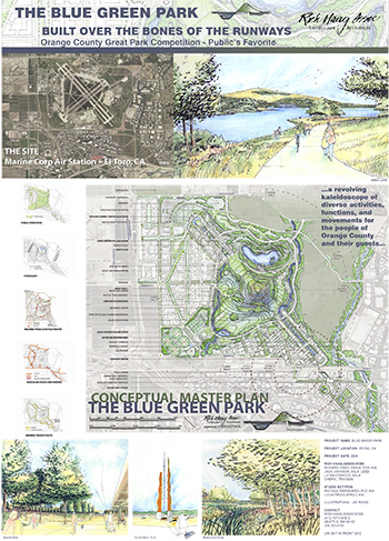
Title: The Blue Green Park Built Over the Bones of the Runways
Project: Blue Green Park – Orange County Great Park Competition – Public’s Favorite
Firm: Richard Haag Associates
Summary: A revolving kaleidoscope of diverse activities, functions, and movements for the people of Orange County and their guests.
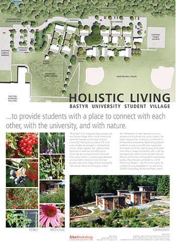
Title: Holistic Living: Bastyr University Student Village
Project: Bastyr University Student Village
Firm: Site Workshop
Summary: The product of an integrated design process, the new Student Village offers a multi-dimensional residential experience that supports Bastyr University’s healing arts curriculum. The small-scale cottages are arranged in neighborhood clusters, woven together with a permaculture landscape of medicinal and edible plants. Central garden courtyards extend communal living space outdoors and encourage interaction among students. Stands of preserved trees provide scale to the village, while embracing the site’s natural history and ecological context.
With deliberately compact development and a reluctance to disturb existing natural systems, the project expresses the University’s commitment to environmental stewardship. Replenishing adjacent wetlands, an extensive biofiltration swale treats stormwater runoff from parking areas, while green roofs attract a range of pollinators with a specially developed plant palette. Combined with resource efficient construction and high-performance energy systems, these features contributed to a LEED Platinum certification—the first in the country for a student housing development—as well as the USGBC’s Outstanding Multifamily Project award.
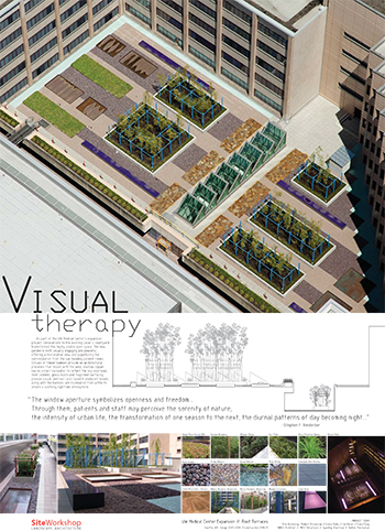
Title: Visual Therapy
Project: UW Medical Center Expansion // Roof Terraces
Firm: Site Workshop
Summary: As part of the UW Medical Center’s expansion project, renovations to the existing Level 4 courtyard transformed this highly visible open space. The new garden is both visually engaging and peaceful, offering a restorative view and opportunity for contemplation from the surrounding patient rooms. Groves of timber bamboo provide an architectural presence that moves with the wind; shallow copper basins collect rainwater to reflect the sky overhead; river cobbles, glass mulch and flagstone surfacing provide visual contrast; and raised translucent bands, along with the bamboo, are illuminated from within to create a soothing nighttime atmosphere.
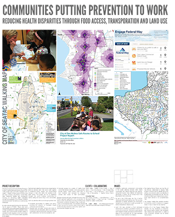
Title: Communities Putting Prevention to Work: Reducing health disparities through food access, transportation and land use
Project: King County Communities Putting Prevention to Work – Health Eating and Active Living (CPPW-HEAL)
Firm: SvR Design Company
Summary: The King County Communities Putting Prevention to Work-Healthy Eating and Active Living (CPPWHEAL) project was a joint effort between Public Health – Seattle & King County (PHSKC) and the cities of Burien, Des Moines, Federal Way, Kent, Redmond, SeaTac and Snoqualmie, focusing on diminishing health inequalities through the reshaping of the “policies, systems and environments” that define our contemporary landscape.
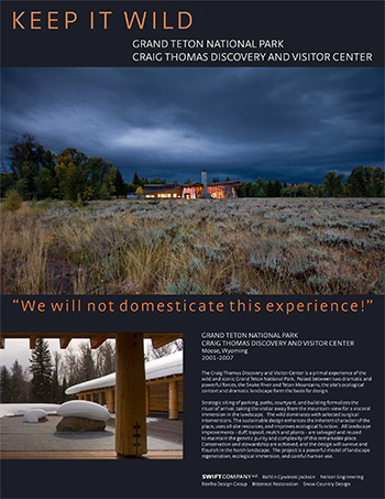
Title: Keep It Wild
Project: Craig Thomas Discovery and Visitor Center, Grand Teton National Park
Firm: Swift Company
Summary: The Craig Thomas Discovery and Visitor Center is a primal experience of the wild and iconic Grand Teton National Park. Poised between two dramatic and powerful forces, the Snake River and Teton Mountains, the site’s ecological context and dramatic landscape form the basis for design.
Strategic siting of parking, paths, courtyard, and building formalizes the ritual of arrival, taking the visitor away from the mountain-view for a visceral immersion in the landscape. The wild dominates with selected surgical interventions. The sustainable design enhances the inherent character of the place, uses all site resources, and improves ecological function. All landscape improvements – duff, topsoil, mulch and plants – are salvaged and reused to maintain the genetic purity and complexity of this remarkable place. Conservation and stewardship are achieved, and the design will survive and flourish in the harsh landscape. The project is a powerful model of landscape regeneration, ecological immersion, and careful human use.
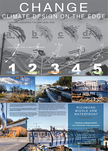
Title: Change: Climate Design of the Edge
Project: Richmond Middle Arm Waterfront
Firm: Todd Bronk
Summary: Respecting and reflecting the natural fluvial forms and functions of the river, the design team created a unique series of experiences along 1.3 kilometers of the Richmond waterfront. Braided pathways follow undulating landforms along the shoreline. Restorative plantings and native landscapes visually connect and unify a series of attractive public spaces, transit alternatives, and the Olympic Oval.
Users experience the tides and ecology of the river along with activities and entertainment in the diverse public spaces and play areas integrated into the serpentine dike. Focused views of the Fraser River and Coast Mountain Range are enhanced by the crowds cheering on dragon boat races and the airplanes overhead.